Start
End
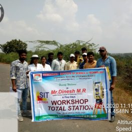
A Report on “LAND SURVEY USING TOTAL STATION CERTIFICATION COURSE”
25-2-2020 to 29-2-2020
Mr. Dinesh M.R, Trainer
From LSIT, CHENNAI
DAY 1:
The lecture on TOTAL STATION: Basics of surveying, History of surveying, Fundamentals of surveying, Knowledge on coordinates, Area calculation, Graph method coordinate extraction, what is TOTAL STATION, its advantages, Precautions to be taken while handling the instrument, Components parts of TOTAL STATION. In the Afternoon Session, Distance measurement by using footsteps was practiced. Instrument setting: Fixing the Total station, setting the instrument was practiced in the field.
DAY 2:
On the Day-2, 10 teams were divided containing 10 members in a team with a special trainer attached to each team. Session started with setting up the instrument i.e. Centering, Levelling, Temporary adjustments in the instrument. Later on, Boundary survey was practiced by taking the back sight point and temporary benchmark. Thereafter, Layout survey, road survey and topographical survey was practiced in the GIST campus surroundings.
DAY 3:
On the Day-3, Benchmark setting, Spot levels, Contour survey was practiced in the morning session. In the afternoon session, Layout marking, Pile marking, column marking was practiced with the instrument and the data was saved in the memory as well as manually in the coordinate system.
DAY 4:
On the day-4, GIST campus building is allotted to each team and asked to do the survey and collect the data individually in the coordinate system with a number of change points.
DAY 5:
On the Day 5, all the students were taken to a surrounding hill station named NARASIMHAKONDA which is around 15km from the college and there, the students were asked to do the topographical survey along the existing ghat roadand prepare a rough map.
DAY 6:
On the 6th day, in the morning session, the collected data of each team was transferred from the memory to AUTOCADD software and calculated the area of GIST campus and also prepared a map of the ghat road.
In the afternoon session, a test was conducted to all the students and for all the qualifiers; a certificate was given by assembling all the students in a DIGIHALL.