A Report on Remote Sensing & Geographical Information System
Start
End
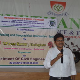
Remote Sensing & Geographical Information System
Course Duration: 22/08/2016 to 26/08/2016
Topic: Remote Sensing & Geographical Information System
Speaker: V. Pavan Kumar, Site Engineer, Pardha Elites Construction, Sullurupeta.
Description:
An event of 5 days course was conducted to the III year students of Dept Civil Engineering Dept by Sri V. Pavan Kumar, Site Engineer, Pardha Elites Construction, Sullurupeta
- The course created great exposure to students in gaining knowledge on concepts and applications leading to modelling of earth resources management using Remote Sensing
- The resource person discussed the topics over Generating geographical information by processing digital remotely sensed data.
- Given briefs on how to critically evaluate the use of GIS for human security and environmental applications
- Students got scope to acquire skills in storing, managing digital data for planning and development and also had a platform for enhancing their skills in advance techniques such as mapping, modelling and monitoring the geographical information.
- The course was fully equipped with concepts, methodologies and applications of Remote Sensing Technology. Mainly given salient inputs for Civil Engineering stream on use of diverse techniques and instruments adequately to measure, locate and find bearings on a map and in a field.
- Students pursued the ultimate use of GIS software to perform different spatial analysis and satellite image digital analysis and attained knowledge on preparing documents of medium complexity, consisting of text, maps, graphs and tables to clearly present the design specifications of a data model for GIS application.